
|
You can't miss Venus beaming down as daylight fades. In just a few days time, on Friday 27th March, it reaches dichotomy when it shows a perfect half phase. It is now almost at its greatest elongation from the Sun and won't set until near 11pm. Venus is so bright that a great moment to observe it is whilst there is still some daylight in the sky. It looks like a tiny featureless Moon. Here's a quick iPhone photo I took yesterday in fading daylight through the eyepiece of my telescope: 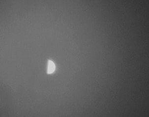 And Venus is still getting brighter. It is swinging towards the Earth but declining in phase to a crescent. These competing effects reach tipping point at the end of April when Venus peaks in brightness at an amazing magnitude -4.5! Make sure you catch Venus over the next few weeks, it's a beautiful sight.
2 Comments
IF ONLY WE KNEW! As we all do know, forecasting is always difficult, especially of the future. In a maritime climate like ours it’s even harder. In Earth’s atmosphere, most of what we refer to as ‘weather’ takes place at the lower level where we all live – the troposphere. Above this lies the stratosphere. The boundary between the troposphere and the stratosphere is called the tropopause. The precise height of this region depends on our latitude and the timer of year (i.e. where the Earth is in its orbit). In the lower stratosphere, there is a very dynamic wind system known as the jet stream which has a strong influence on our weather down in the troposphere. Jet stream winds can regularly reach over 100mph and are a reason why it can take less time to fly west to east over the Atlantic than it takes to fly east-west. In the images below, the red plots show the strongest jet stream winds. You can obtain a jet stream forecast up tom 10 days into the future at https://www.netweather.tv/charts-and-data/jetstream As a rule of thumb, if the jet stream winds are:
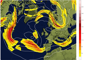
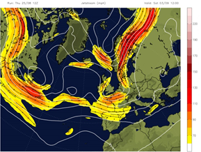
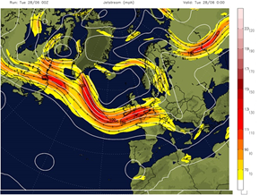 These are not infallible rules, but do give a strong indication to help plan your observations.
|
AuthorWMA members Archives
July 2024
Categories |
 RSS Feed
Proudly powered by Weebly